-40%
Bluechart g2 HXUS039R USA Coastal Chart in microSD/SD map card for compatibles
$ 17.41
- Description
- Size Guide
Description
Bluechart G2 - HXUS039R - USA Coastal Chart - microSD/SD map cardPackage includes: Micro SD card with an optional full size SD adapter, protective case.
Works in GPS models listed in the compatible device list.
You may use HomePort on your computer with this digital map to plan your routes/trips.
At checkout, leave us a message/note indicating your GPS model.
Domestic shipping is via USPS first class with tracking, expedited shipping is available.
Features on BlueChart g2:
·
·
Includes realistic navigation features showing everything from shaded depth contours and coastlines to spot soundings, navaids, port plans, wrecks, obstructions, intertidal zones, restricted areas, IALA symbols and more.
·
Features smooth displays, including seamless transitions between zoom levels and more continuity across chart boundaries.
·
Allows users to choose between standard 2-D direct overhead or 3-D "over the bow" map perspective to make chart reading and orientation easier.
·
Provides Safety Shading (in compatible units), allowing mariners to enable contour shading for all depth contours shallower than user-defined safe depths.
·
Provides Fishing Charts (in compatible units), allowing mariners to scope out bottom contours and depth soundings with less visual clutter on the display.
Coverage:
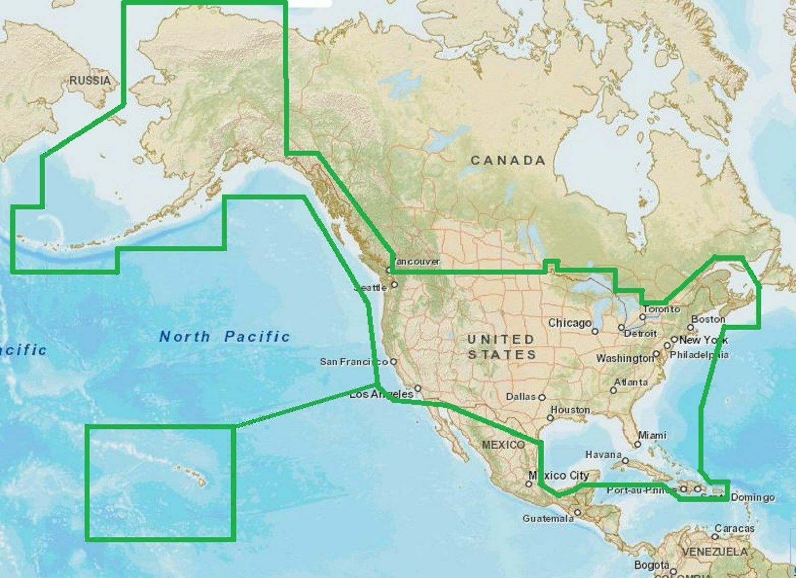
Provides detailed coastal coverage of the U.S., including the East Coast from Key West, FL, to the Canadian border, and the West Coast from Puget Sound to the Mexican border; Alaska; Hawaii and major inland rivers; the U.S. Gulf Coast to the Mexican border and the Mexican Gulf Coast to the Yucatan. Canadian coverage includes the entire St. Lawrence Seaway, Nova Scotia and New Brunswick. The Great Lakes are covered in their entirety as are the Lake of the Woods. Coverage includes Prince Edward Island, Anticosti Island, Vancouver Island, including the Inside and Outside Passages, the Aleutian and Channel Islands, the Bahamas, the Turks and Caicos Islands, Cozumel, Cuba, Hispaniola, Puerto Rico and the U.S.Virgin Islands.
Compatible Devices:
Alpha® 100
Astro® 320 / 430
Dakota® 20
eTrex® 20 / 30 / Touch 25 / Touch 35 / Touch 35t
echoMAP™ 43dv / 44dv / 50dv / 50s / 53cv / 53dv / 54dv / 70dv / 70s / 73dv / 73sv / 74sv / 93sv / 94sv
echoMAP™
CHIRP
42cv / 42dv / 43cv / 43dv / 44cv / 44dv / 45cv / 45dv / 52cv / 52dv / 53cv / 53dv / 54cv / 54dv / 55cv / 55dv / 72cv / 72dv / 72sv / 73cv / 73dv / 73sv / 74cv / 74dv / 74sv / 75cv / 75dv / 75sv / 92sv / 93sv / 94sv / 95sv
NOT for the echoMAP Plus and echomap UHD series!
GPSMAP 276Cx / 4008 / 4010 / 4012 / 4208 / 420/420s / 421 / 4210 / 4212 / 431 / 431s / 441 / 441s / 5008 / 5012 / 5015 / 5208 / 521 / 5212 / 5215 / 520/520s / 521s / 526 / 526s / 531 / 531s / 536 / 536s / 541 / 541s / 545/545s / 546 / 546s / 62 / 6208 / 6212 / 62s / 62sc / 62st / 62stc / 64s / 64st / 640 / 66s / 720 / 720s /
721xs /
7212 / 7215 / 740 / 7407 / 7407xsv / 7408 / 7408xsv / 740s / 741 / 741xs / 7410 / 7410xsv / 7412 / 7412xsv / 7416 / 7416xsv / 7607 / 7607xsv / 7608 / 7610 / 7612 / 7616 / 78 / 78s / 78sc / 840xs / 86i / 86s / 86sc / 1020xs / 1040xs
Colorado® 300 / 400c / 400i / 400t
Montana® 600 / 600t / 610 / 610t / 650 / 650t / 680 / 680t
Monterra
Oregon® 450 / 450t / 550 / 550t / 600 / 600t / 650 / 650t
Rino® 750 / 755t
If you have questions, please let us know.
Buy with confidence from a
n eBay
verified seller - you are protected!
SATISFACTION GUARANTEED OR YOUR MONEY BACK!
If you are not satisfied with your purchase for any reason you may return it to us within 30 days for full refund.
SHIPPING
:
The sale includes a pre-loaded microSD card. If you need an SD adapter, please notify us to include one by the “
Message to seller
” button at the check-out screen. We ship out in the next business day after receive payment.
The default shipping option is a 4-day standard shipping to any US territories
.
OpenStreetMap® is open data, licensed under the Open Data Commons Open Database License (ODbL) by the OpenStreetMap Foundation (OSMF)
"Garmin" is a registered trademark Garmin Ltd
Photos are for reference only
